Il terremoto
Blog Week #3
Il terremoto…Earthquakes in Italy
This week we are talking about earthquakes. Earthquakes can happen when one tectonic plate moves under another, slides past another, or collides with another. (See my blog from last week.) This shaking of the earth causes vibrations that can be measured. Usually we refer to the vibrations as seismic activity. Usually the magnitude of an earthquake is reported and a trusty site that I use for recent earthquakes is from the United States Geological Survey (USGS) website for the latest earthquakes: https://earthquake.usgs.gov/earthquakes/map/?extent=15.53838,-132.45117&extent=55.77657,-57.48047. The magnitude can be small or large and is measured, but the main thing to know is that an increase of 1.0 on the magnitude scale is a ten-fold increase. Generally, according to Michigan Tech, an earthquake that is less than 2.5 on a magnitude scale can be recorded by a seismograph but usually not felt, whereas a magnitude 6.1 or greater quake can cause quite a bit of damage in very populated areas.
Here is what I found out about Italy…
Italy is one of the most seismically active countries in Europe! Last week I talked about why that is: Italy is located where the Eurasian plate meets the African plate. In addition, I mentioned that Italy has several smaller fault zones along the Apennine Mountains, and is affected by plate tectonics in nearby regions, that causes a chain of seismic events.
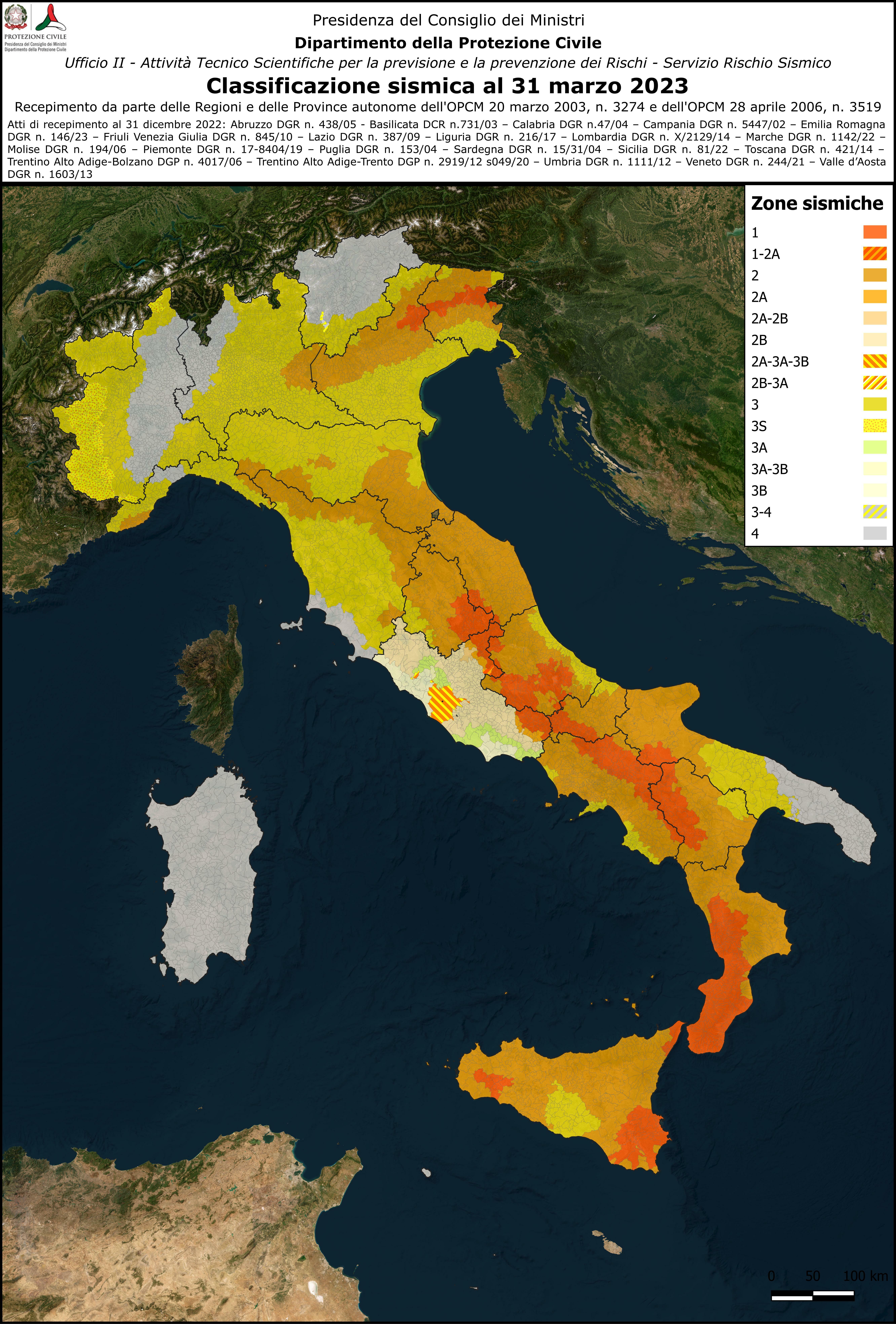
Italy is divided into 4 seismic zones.
Zone 1 has high seismic risk
Zone 2 has medium-to-high seismic risk
Zone 3 has medium-to-low seismic risk
Zone 4 has low seismic risk

Source:
The map displayed above is one way that Italy is trying to prevent an earthquake catastrophe. There were major earthquakes this century that has prompted the Italian government to act. The first was a 5.8 or 5.9 quake in L’Aquila in 2009 and it caused 309 deaths. As a result, the Italian government implemented the comprehensive National Seismic Prevention Plan (NSPP) to minimize the loss of human life. The focus of this plan was to improve infrastructure and emergency response.
Source: https://www.cdri.world/g20-drrwg-case-study/36

Photo of 2009 L’Aquila earthquake damage
Source: https://en.wikipedia.org/wiki/2009_L'Aquila_earthquake
The next major quake that spurred change was the 2016 Central Italy’s Amatrice earthquake that had a magnitude of 6.2. According to the BBC, at least 297 people died as a result of that quake, including 26 children when a school collapsed.
Sources: https://www.bbc.com/news/world-europe-37390893

Damage caused by the 6.2 2016 earthquake in Amatrice.
Source: https://en.wikipedia.org/wiki/August_2016_Central_Italy_earthquake
After that quake, the Italian Prime Minister, Matteo Renzi, planned to introduce “Casa Italia” with an aim of improving the seismic safety, especially in schools. Unfortunately, I could not find recent information about Casa Italia.
Source: https://www.undrr.org/news/italy-commits-long-term-earthquake-preparedness
Last, but not least, here is a map of 2024 activity

Source: https://ingvterremoti.com/2025/01/13/speciale-2024-un-anno-di-terremoti/


Very nice post, it is very interesting to see the comparison of different regions around the world. Your country of Italy has way more activity than my country of Russia and it is interesting to see.
ReplyDelete